Enjoy Glenorchy's Natural Beauty
Did you know Glenorchy has its own beach — and not one but two scenic waterfalls? There’s far more to this city than meets the eye, and it rewards those who take the time to explore.
From the Derwent River foreshore to the bushland slopes below kunanyi / Mount Wellington, the municipality includes a range of parks, reserves, waterways and trails that support both biodiversity and community wellbeing.
These natural areas are an important part of Glenorchy’s identity and contribute to the lifestyle enjoyed by residents and visitors alike.
Volunteering
The Glenorchy City Council’s Natural Areas Engagement Program is dedicated to creating opportunities for community involvement in preserving and enriching our local natural areas within Council-managed reserves.
Kunanyi/Mount Wellington
kunanyi / Mount Wellington forms a dramatic natural backdrop to Glenorchy and is one of Southern Tasmania’s most significant natural landmarks.
The mountain and its surrounding foothills provide opportunities for:
- Bushwalking and hiking
- Mountain biking
- Nature photography
- Wildlife observation
- Outdoor recreation and exploration
The Glenorchy Mountain Bike Park, located on the lower slopes of the mountain, attracts riders from across Tasmania and beyond with a network of purpose-built trails and riding areas.
Bushland areas near the mountain also support native wildlife, significant vegetation communities and scenic walking routes.
Wellington Park
Wellington Park
Wellington Park dominates our city skyline with over 4000ha of bushland and making up around one third of our municipality. The Glenorchy section of Wellington Park has large parts that cover protected drinking water catchments.
There are no public roads and the feel is less busy compared to the Hobart side, which attracts most of the visitors via The Springs and Pinnacle Road.
The main access to Wellington Park is via the Glenorchy Mountain Bike Park at the end of Tolosa Street. Several fire trails suitable for walking extend from the Glenorchy Mountain Bike Park to other areas within Wellington Park.
There are some spectacular views for those willing to walk up the trails to Mt. Arthur, Tom Thumb and nearby points.
Wellington Park Tasmania has an interactive dog walking map.
Dogs on a lead, of no more than 2 metres, are permitted in several areas in Wellington Park. These areas are defined in the Management Plan and allow for substantial dog recreation and exercising opportunities in both the Hobart and Glenorchy municipal areas while preserving the natural values of Wellington Park.
Click this link to check out the interactive dog walking map.
Derwent River foreshore
The Derwent River foreshore is a key environmental and recreational feature of the municipality.
The foreshore includes walking and cycling paths, wetlands, open spaces and natural habitat areas that support waterbirds and other wildlife.
Residents and visitors can enjoy:
- Shared walking and cycling paths
- Picnic and barbecue facilities
- Birdwatching and nature observation
- Scenic river views
- Fishing and passive recreation
The foreshore also includes the popular GASP! (Glenorchy Art and Sculpture Park) precinct, which combines public art, open space and waterfront recreation.
Humphreys Rivulet path
The Humphreys Rivulet path is a peaceful and accessible walking route that follows the rivulet through parts of Glenorchy.
The trail provides opportunities for walking, exercise and quiet enjoyment of green space close to urban areas.
Vegetation along the rivulet also supports local biodiversity and contributes to the environmental health of the municipality.
Humphreys Rivulet Path Works
Nestled between kunanyi / Mount Wellington and the River Derwent, Humphreys Rivulet winds its way through the Glenorchy municipality, tracing a path from its steep upper catchments down into the heart of the urban area.
Steep terrain in its headwaters means that heavy rainfall can turn the rivulet into a fast-moving force, prone to flash flooding and capable of carrying debris downstream. Overflows from Humphreys Rivulet are a major contributor to flood risk in parts of Glenorchy, particularly across the flatter floodplain around the CBD.
At the same time, the rivulet is more than just a drainage channel. It offers potential as a green corridor and community amenity. Plans are underway (or under discussion) to rehabilitate portions of its course, improve its environmental quality, and better integrate it into urban open space. There is particular interest in creating a shared walking / cycling path along or near the rivulet as a safer and more pleasant alternative to busy roads like Tolosa Street.
Humphreys Rivulet thus sits at the intersection of natural hazard and opportunity — a waterway that demands respect, careful planning, and offers a chance to enrich Glenorchy’s landscape, resilience, and connection to nature.
We’re preparing to upgrade the path along Humphreys Rivulet.
Bushland and Foreshore Reserves
Council manages a range of bushland reserves throughout Glenorchy that protect native vegetation, wildlife habitat and natural landscapes.
These reserves include areas of dry forest, gullies, creek corridors and natural open space that provide refuge for birds, mammals and plant species.
Bushland reserves are open for low-impact recreation and community enjoyment, including:
- Walking and bushwalking
- Birdwatching
- Nature appreciation
- Environmental education
- Volunteer conservation activities
Council undertakes ongoing land management, weed control, habitat restoration and conservation work to help protect these natural environments.
Glenorchy’s natural areas support a variety of native wildlife and plant species.
Wetlands, waterways, bushland and foreshore areas provide habitat for birds, waterbirds, reptiles, insects and other native fauna.
Protecting biodiversity and maintaining healthy ecosystems are important parts of Council’s environmental management and sustainability programs.
N.R. Pierce Reserve
The N.R. Pierce Reserve is a significant bushland reserve donated to the people of Glenorchy by the Pierce family in 1988 in memory of Norman R. Pierce and his significant contribution to the community.
The reserve is an important native bushland backdrop to Glenorchy.
The reserve covers 449ha behind Berriedale and Montrose and to the east of Collinsvale. It borders Wellington Park to the south-west.
The reserve contains a wide variety of vegetation types and the reserve provides important habitat for a variety of birds, mammals – including bettongs, bandicoots, Tasmanian devils and wallabies – reptiles, amphibians, and insects.
Access to N.R. Pierce Reserve is on existing fire trails which connect through to Wellington Park. The Zig Zag Track from Collinsvale Road is the main access point for visitors.
Poimena Reserve
Poimena Reserve is situated on top of a small hill in Austins Ferry. It is 29ha and offers panoramic views of the Derwent River to the east, and kunanyi/Mount Wellington to the west. Visitors can enjoy a diverse walking experience through a mix of native white gum, peppermint and blue gum woodland and managed parkland.
The reserve supports a range of fauna including bandicoots and over 70 native bird species. Several rare beetles and herbaceous plants also occur there.
There are BBQ facilities and the reserve is home to southern Tasmania’s only disc golf course.
Access is via Wakehurst Road, Austins Ferry.
Gould’s Lagoon
Gould’s Lagoon in Granton was designated as a wildlife sanctuary in 1938 at the request of the owner at the time, Arthur Gould. It is a particularly important refuge for water birds which use the area for resting, feeding and breeding. A viewing platform can be accessed by a boardwalk across the water. This is a great place to observe the birdlife visiting the lagoon. The car park is located off Hestercombe Road.
Jim Bacon Memorial Reserve
Jim Bacon Memorial Reserve in West Moonah contains a mix of open parkland and a 2ha remnant patch of rare black gum forest. Several rare plants are found here including Blue Devil, a small, prickly herb with distinctive blue foliage.
The reserve also provides habitat for several bird species including the threatened Swift Parrot.
Access is from Devines Road, Thornleigh Street and Hudson Crescent.
Amy Street Community Park
This 5ha reserve of remnant bushland is situated at the top of Amy Street in West Moonah. The reserve contains some significant native grassland, white gums, peppermints and she-oak forest. It provides a quiet walking location as well as great views towards the east and north from its elevated position.
Access is from several points in Moonah and West Moonah including Amy Street, Seventh Avenue, Wilkie Court, Walch Avenue and Bermuka Street.
Lutana Woodlands Reserve
Lutana Woodlands Reserve provides one of the best panoramic vistas in the city, with sweeping views over Glenorchy, nearby suburbs and the Wellington Range. Tracts of remnant native grassland support over 40 native plant species including grasses, herbs, orchids, shrubs and trees.
In recent years we have worked with the local community on restoration works, planting hundreds of trees and shrubs, removing rubbish and clearing weeds.
The park is popular with dog walkers.
A car park is located off Bowen Rd and there is also access from Lennox Street.
Winderemere-Berriedale Foreshore
The foreshore from Claremont to Berriedale is a varied landscape. Several local reserves are linked to make an extended walking trail stretching along the Derwent from Cadbury through to Mona at Berridale.
The track passes environmentally significant salt marsh, open parkland, headlands, sheltered bays, and bush tracks containing she-oaks. There are some spectacular views along the walk. The area also has significant Aboriginal heritage importance.
Elwick Bay Foreshore (GASP!)
Fringing Elwick Bay from Montrose Foreshore Community Park to Wilkinson Point, is the Glenorchy Art and Sculpture Park (GASP!). The sealed path and boardwalk guides you past open parkland, a regenerating dune, tidal wetlands and saltmarsh. Highlights include scenic vistas, art displays and sculptures and bird watching opportunities.
Getting out in nature
There are many opportunities to explore Glenorchy’s natural areas through walking tracks, shared-use paths and recreational trails located throughout the municipality.
Maps and information about walking and cycling routes, parks and reserves are available through the Discover Glenorchy mapping tool.
The mapping tool can help residents and visitors find nearby trails, open spaces, recreational facilities and natural attractions across Glenorchy.
- Collinsvale — a scenic drive through one of the area’s most picturesque rural villages
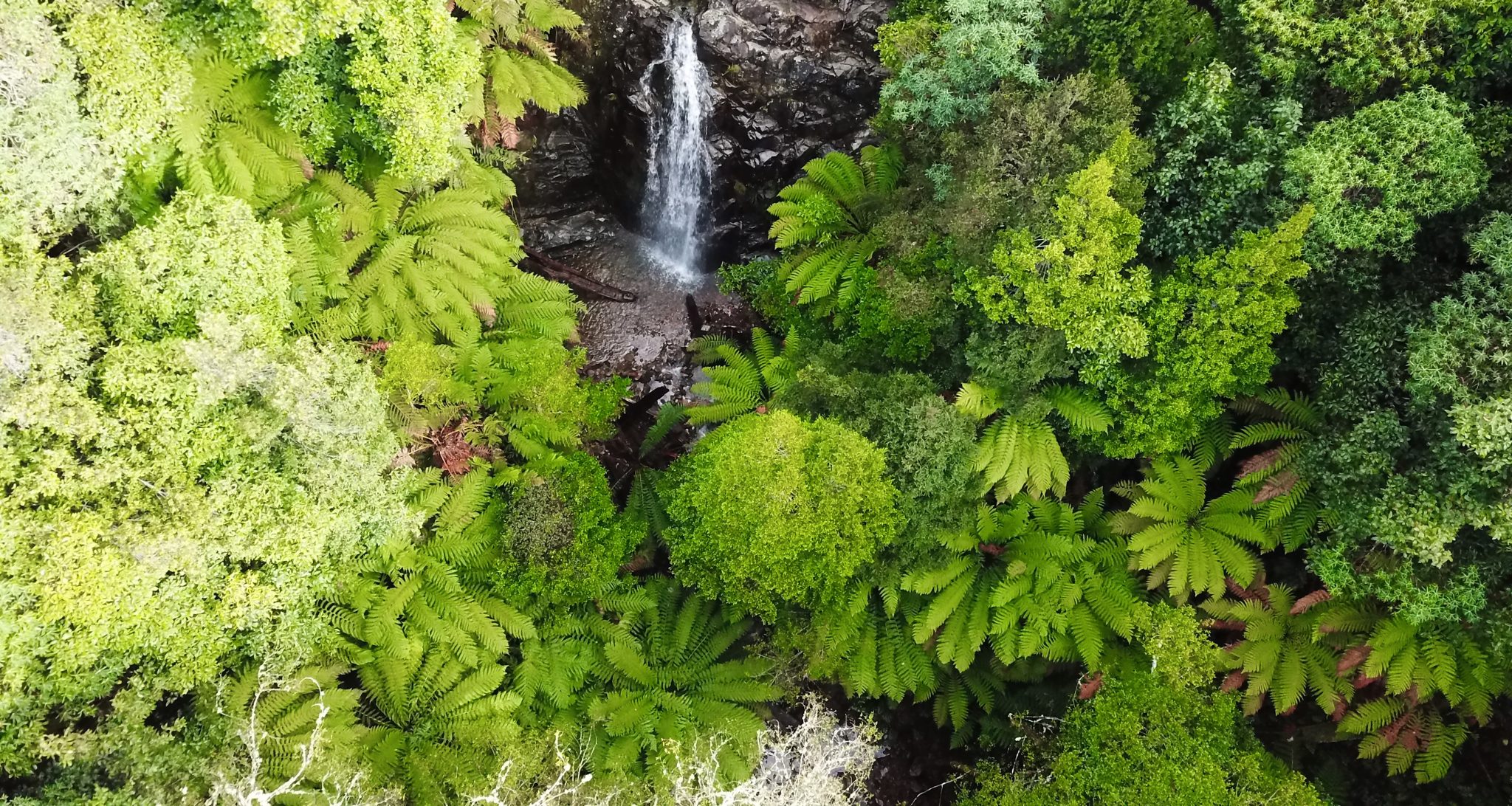
- Myrtle Forest & Waterfalls — walk through lush cool-temperate rainforest and discover the falls tucked within
- Gould’s Lagoon — a peaceful wetland sanctuary and haven for native waterbirds
- North South Track — a fantastic route for walkers and cyclists taking in the landscape
- Glenorchy Mountain Bike Park — set in the foothills of kunanyi/Mount Wellington, this is prime riding territory, with Tolosa Park and beyond offering great options for walkers too
Check out our parks and open spaces page for resources on where to start.
Unsure what something on this page means? Check out Our Glossary.